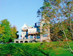
We woke to a stunningly good morning. Not a cloud. Deep blue August mountain morning sky. Dew glistening off the beech trees. Great visibility: you can make out individual trees on top of Banks Hill by standing on the west side of the dining hall (it's a view of Banks I'd never stopped to look at before - and I caught it with my camera).
 While I was standing there outside the dining hall (while Camp Hird was eating breakfast and while Wawayanda was back in the villages cleaning cabins) I looked over at the Carl Hess Pavilion, which we've used for our outdoor barbecues until the construction of the new Wellness Center began. For the second time in its career, Carl's pavilion was used as a warm supply hut/break-station for construction crews...first in the 1983-85 period during the building of the new dining hall and now again in 2007-08 for the Guenther Family Wellness Center. Soon we'll either start cooking in Carl's pavilion again or we'll move it down the hill and put on the chicken and burgers there. It's possible we'll be moving laundry out of the main part of camp (it's still in the old Forstmann-era bullpen) and put the Hess structure in its place, so that it'll be near the Halbe & Jane Brown pavilion, which is an excellent large covered space for rainy days. The two would work well together, just as Halbe and Jane and Carl and Marie always did.
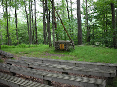
 Now I pivoted northward and looked at the scene before me and asked myself, What am I seeing here that I've always seen? Certainly not the dining hall parking lot. the very road we use to drive up to the dining hall was not there until '86. Prior to that one used a rocky trail to walk up from the Big Tree Field to the dining hall area or to cabins 21-25 (Hemlock village in those days). But there it was: the old Rifle Range Road, making its way steeply up the hill from the dining hall to what was then the furthest distance up the hill (really a foothill of Doubletop) on which the villages are laid out. Up past old Lenape on the west side of Hemlock Brook/Trickle Brook (cabins 16-20 and now 13-17 were built on the east side of that sometimes flowing creek). Kresge Lodge is now almost exactly where the Rifle Range used to be. But the Rifle Range Trail (now without a name) is still there, the first part of it more or less exactly as it ever was. Quite a beautiful walk through the woods there. It beckons.
At the bottom of this entry I've included a portion of the camp map made in 1970. I've marked the Rifle Range Trail in blue.
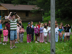
 Finally I turned due west and walked about 100 feet in the direction of cabins 21-25, old Hemlock, now the village where Pocohontas and Totem are combined into one youngest group. These cabins have been replaced by nice new cabins (laid out in the same way as the old ones but much sturdier) put in exactly the same spots as the old ones. In this picture you see only cabin 24, but imagine to the left of the shot cabin 25 sitting near the brook across from the dining hall. To my extreme right stands 21, and just off to the right and beyond are 22 and - in its corner against what used to be the Deus property - the nestled cabin 23. Arguably 23 is in the nicest spot for a cabin in camp. I'd also vote for cabin 40 (what used to be 10) and also cabin 17 (what used to be 20). Fans of the cabins will approve, I think, of what's been done to restore this semi-circular village arrangement. This is now where Wawayanda holds its morning flag raisings - making it super convenient for the youngest kids to roll out of bed and hear the morning announcements, praise the core value of the day, hear pearls of wisdom and sing a silly song to start the day.
Start the day.... Although it's the beginning of the final week of camp and the staff have led the programs they will lead today a dozen times already this summer, one senses it will be a great morning.