Showing posts with label overnights. Show all posts

Wednesday, June 25, 2014

a "chef-off" on a night that was supposed to be a washout

Rain drove all the village staffs under cover tonight, but Lincoln McLain (Adventure Director) and his staff, including Zach (Adventure Coordinator), were keen to teach how to lead a good overnight hike and campout anyway. So all around camp there were sessions being conducted on setting up tarps, devising activities for the campsite, and (of course) cooking. I was invited to join this three-team gang: Adventure Village staff, Adventure Trip leaders, and CIT coordinators. So these are the folks who will be doing this kind of camping and cooking a whole lot in the coming two months. Zach "gamified" the cooking plan. He announced a chef-off. Each group was giving a bunch of ingredients, plus oil and a stove, a pot, and a pan, and some utensils. Then, "go!" - they had an hour exactly to present a three-course meal - appetizer, entree, dessert. Bud Cox and I were dubbed judges. Below you have a video of Zach describing the rules, and below that some of the photos of the action and the results.


Once Bud and I judged the results, everyone dug in, happily. I had the distinct feeling that this summer the kids going on hiking and canoeing trips with these adventure leaders will be eating very well. Lincoln and Zach proved to them that cooking out on the trail can produce really tasty--and even spicy (we had a macaroni curry!)--meals.

Then it got dark and the rain came down in sheets. It pounded on the metal roof of the Halbe & Jane Brown Pavilion, and it was time for a re-naming ceremony. Those who were being inducted into these groups (I can't tell who were were - but let's just say we were deemed "new" to the adventure units) were to be given "knuck names." We had four-letter words drawn just above the knuckle of four fingers on each hand, and could not look at these two words. Held our hands behind our backs as every formed a circle around us. They we loudly announced, each in turn, "I used to be called such-and-such, and now my name is such-and-such." Parker Van Nostrand was now "Luck Shak." I am "Lucy Star" (very nice). It was a hilarious and actually, in a bizarre way, very beautiful thing to be told you are a friend of the adventure team in this whacky adventure-ish mode.


Sunday, July 29, 2012

a plea for Pigeon Brook

In this immediate area Pigeon Brook is probably the body of water that suffered the greatest damage from Hurricane Irene last August 27-28. Or let's put it this way: the ways in which this brook was changed are still almost entirely apparent.
Pigeon has always been my favorite stream here, and it has some serious competitors.
There's the stateliness and historical significance of the main river flowing through our land - the Neversink, a mecca for flyfishermen starting with the Dutch in probably the 17th century - a classic.

High Falls Brook above the falls itself is a lot like Pigeon, actually, but below it it's slower, wider, more "obvious" than Pigeon. And it has a reason for going: High Falls. Forgive me for putting it this way, but it's like a tourist-destination stream. Not for me when I want the real thing. I've climbed up all the way along High Falls Brook to its source, up a ridge of Doubletop and is probably the best way these days to get up Doubletop. So H.F.B. is special to me but still there's that hike-a-little get-big-payoff thing that seems facile. Hemlock Brook aka Trickle Creek isn't really much and it runs right through the middle of camp, so it hardly counts, and it's dry a lot of the year. It does, when it's been raining a lot, go through the middle of Big Tree Field and that's a nice feature.I don't know if the stream that once flowed through the meadow that is now Lake Cole ever had a name. I suspect not. Two or three streams feed the man-made lake. Anyway, that can't count, can it?
The East Branch of the Neversink flows down the back side of slide, picks up real stream status through the Tison preserve (Frost Valley land), then passes right next to the old Straus estate (now East Valley Ranch, also FV), passes across the road from our Farm Camp (where the kids actually have their "waterfront" period in one of its deep-ish holes) and flows all the way to Claryville, where, just at the famed turn-off to county road 47 and the 7 miles to Frost Valley's main property, the two branches of the early Neversink converge. I love the East Branch and it's getting to be one of those rivers I can drive next to and feel lots of feelings. For one thing, as I drive alongside it toward and at the Tison property, near the head of the Denning trail, I can fool myself into believing that I'm existing in 1870 or 1890.

Biscuit Creek - she's got to be at least everyone's second favorite. Biscuit is what you think of when you think of this part of the Catskills. Really gorgeous. Moves slowly and knows where it's going. Flumes here and there cut through the glacial boulders - making mesmerizing features such as Devil's Hole. It's easy to hike alongside. The train dates back at least to Forstmann's time, when he laid down felled Hemlock trunks on the creek-side edge of the trail, and rode big horses pretty far down the river. I think of Biscuit Creek as Forstmann's stream. The storm messed with Biscuit down near the open fields of camp and down to where it joins the Neversink. Damage upstream is not so horrid. It still looks like Biscuit. (Above: Biscuit Creek falls a few years ago.)
But Pigeon Brook. It's crazy and it's wild. It drops from around 3750 feet at its 2-pronged source, up near the top of of Doublestop, to the spot (right at Sequoia) where it meets its calm brother Biscuit at around 2000 feet (the bottom of our valley is 1900 feet). That's a steep drop. The Pigeon Brook valley, formed between (and actually dividing) Doubletop Mountain and Big Indian Mountain, is very steep. Thousands of years of erosion and this little feisty waterway has done most of that deepening. At right above you can see a Google Map version of the first part of Pigeon. See where Biscuit, much thicker blue, goes off to the east or right. That's Pigeon, ending at Sequoia, bending up off to the west or left and then turning north and up the mountain. Below you see a satellite photo of roughly the same sector: again, Pigeon off to the left, Biscuit to the right. Pigeon goes almost due north up the mountain. That accounts, of course, for its sections of steep descent.
Yesterday - the Saturday of holdover weekend between sessions 2 and 3 - was the perfect day for a hike up Pigeon. At least by the calendar. By the weather, not so much. An hour into our 5-hike hike up and back it started pouring, and I mean pouring. I hadn't brought rain gear because - what the hell. I knew I'd be scrambling hand and foot up the creek itself much of the time and so I'd be very wet anyway. So I put on non-cotton shirt and shorts no hat and headed out. Along with Dr. Rick Kaskel (another trustee and long-time dialysis doctor and a guy with a replaced hip!) and Bud Cox, who got persuaded to do this hike right there over breakfast, a few minutes before departure. Good ol' Bud. Of course having Bud with us meant that we had
access to a ton of knowledge of Big Indian Mountain and Doubletop and Pigeon itself. So, yes, we spent most of the time going up Pigeon Brook hiking and climbing up in the creek itself. You see, there's a Frost Valley-made trail high alongside Pigeon on the right or east side almost as far as FV property goes. Bud and I recalled for Rick the fact that Frost Valley summer camp overnight hikes went to any of four beautiful Pigeon Brook campsites in the old days. These were named Pigeon 1, Pigeon 2, Pigeon 3, and Pigeon 4. Bud thinks that Pigeons 2 and 4 had lean-to's. I think 1, 2 and 4 did. Anyway, those lean-tos are gone and I strongly urge us to build some new ones. No one - and I mean no one - in camp takes campers hiking up Pigeon. It's a shame. You can say you climbed up part of Doubletop if you do. And of course it's an excellent challenge for the older campers. So I say: less High Falls and less Banks Hill and more Pigeon Brook! The old campsites' clearings are still more or less there and with one day's volunteer work they can be re-made and look welcoming even to novice campers. In some of the photos below you can get a sense of the changes made to Pigeon by the hurricane a year ago. Here for instance is a boulder that got tossed downstream and wedged under a larger bolder while everything under the large bolder got swept away. Now the larger one is being precariously held up by the smaller.
Banks are eroded everywhere, which means that any chance of forging a trail or path along either side of the stream becomes less likely. And everything is soft or crumbly underfoot.

And there are many more little waterfalls and flume-like spots.

Here, below, Bud shows where the waterline was at the height of the storm's violent run-off. This we figured by looking hard at damage, water marks, and erosion. Amazing, eh? When the water was really this high, the entire Pigeon Brook valley was filled with fast-moving water. No wonder the pressure below was so great - on the Biscuit Creek falls in camp, on the bank keeping Pigeon Lodge up out of the stream, on the spot where Biscuit (which Pigeon's water in it) slammed against the southside bank of the Neversink behind the horsebarn.


In the pouring rain, fairly well exhausted from the scrambling ascent on hand and foot in the middle of the brook, climbing over many fallen trees and slipping on tilty rocks that had only been in place for 11 months, we reached the Pigeon Brook fork. Here two feeder streams converge to form Pigeon proper. One goes up and east toward Big Indian Mountain. The other goes up and west toward Doubletop. We went on the northwest fork for a little, then clambered up the steep slope and took a compass bearing west to try to find the deerpath that comes due south down from the top of Doubletop. We didn't get that far and in the pouring rain abandoned the plan to continue to the top of the mountain - and headed at a bearing of 255 degrees. Bushwacked, of course, keeping the Pigeon Valley to our left and staying on a 2500 feet contour for quite a while. Eventually we descended on the same contour and at 2200 feet cross the Frost Valley property line and headed due south into camp. We read the perimeter trail and walked by into camp just to the east of Friendship House and Wolff Lodge. (I add these details in part so others can repeat the trip with some relatively specific instructions.) Dear FV-loving reader of this blog: get thee up Pigeon Brook. What are you doing with your life that you can't spare a day and do this? It's good for the soul: rough hard work, and it fills a longing that camp people have felt every since Wawayanda moved here in 1958, but a somewhat lost art. Go there and be real.


Friday, July 20, 2012

Windsong out


Here's a shot of session 2 Windsong, a few days ago, a few minutes before they headed out on their 2-night overnight to Merrill Pavilion (aka "Pete's").

Wednesday, July 22, 2009

a visit to out-trip

A few minutes ago I ran into my dear pal Ellie Kane who asked me to help her pack Lakota's overnight. So I did and it gave me my first close look at Out-trip in its new setting and mode. Click on the video and you'll get a quickie tour: yes, Out-trip is now in the back of Smith, formerly the dialysis unit. Perfect spot for it, I must say. And Ellie herself lives this summer in the old paymaster's house (sometimes known as the "Flyfishing Shack," so named because for maybe three or four summers it housed flyfishing equipment and was home base for a little-used summer program), so she's often nearby.

Tuesday, June 30, 2009

two-nighter

Windsong (the oldest girls) are leaving this afternoon for a two-nighter, starting at Pete's Pavilion. Here are some of them at lunch. They got their sunglasses, their hiking boots, their braided hair and t-shirts...and seem ready to go.

Friday, January 16, 2009

where have you gone, lean-to?

For years and years, long past the kids in the picture had grown to be adults, this postcard was sold at the "canteen" and later "the camp store." I can only for the moment identify two people in the shot: one, at far left, a camper, is the young Pat Ricciardi. And the counselor stirring the big pot was Lynn Garrison, from somewhere down south (I assume Mississippi). Lynn was probably the VC at the time of this Devil's Hole overnight. Later he was the Program Director (I'm going to guess in '67 or '68). I'll guess that this shot was taken in '66 or '65.

Indeed it was at the Devil's Hole camp site. Today's campers and staff will immediately notice that cooking was being done here from the big pot. Not something done these days. Indeed one probably can't get such a pot to take on an overnight. (Not that I'm recommending the return of these clunkers. I ate too many bad meals from the insides of them in my time.) Since Lynn's stirring the pot we can assume that it's not merely boiled water for hot dogs. I'm guess it's either a big mess of baked beans or some kind of beef stew. About the site: these days the hole area itself - the big flume - is referred to as "Devil's Hole." The hole itself is on State of New York land. So way back, presumably in the late 50s, the camp site was built about 100 years on the camp side (to the west) of the hole, on Frost Valley property, next to a beautiful and less dangerous swimming hole and little waterfall. The whole site - the flume and hole; the camp site just to the west - was called "Devil's Hole." Now the first site is called "Brothers' Hole" and only the main hole (the real attraction) is called "Devil's Hole." Not sure why or when this name change happened. There's a cable bridge at Brothers' Hole, so one can cross and use a new-ish trail to get back to Devil's Hole. In my day there was a nice lean-to built at the camp site. It's long gone, and is a fabulous spot for a new one to be built. (Any volunteers out there wanting to re-build that old lean-to. Excellent for rainy nights out.)
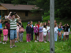
Can anyone identify others in the postcard?

Monday, September 24, 2007

sunrise at Giant Ledge

On the last morning of one of this summer's camping sessions, the Tacoma staff woke up the girls very very early (4 am?) and took them on a sunrise hike up Giant Ledge. Anna Armstrong, one of Tacoma's counselors, took this shot at the sunrise moment.

I think they cooked and ate pancakes up there. Could it get any better than that?

Wednesday, September 19, 2007

a story like an owl hoot in the solitary woods

Alyssa Zuliani was a camper and counselor in the late 70's and 80's (she calls herself "a silent lifer"). When she was in Pokey (her VC was "Patty Pokey" - and also Alyssa's counselor), she writes, "I remember you joining us for a bit on our overnight by the creek and telling us a ghost story - great memory! This is only one of the many great times I remember about FV."

Now a little more about the story, as she remembers it. This is very cool. How articulate and nuanced a memory is this?!

"All I can remember about the story at the moment is that it was scary, but in a lonely way, not a terrifying way. More like the hoot of an owl in the solitary woods, Eros and Psyche-like, than an axe-murderer type! Will try to remember more."

Wednesday, August 29, 2007

thoughts on lax and death

A sunny day...morning after a Forest village overnight: and the staff pack up.

On the left, wearing the light blue staff shirt, is Tor - an ICCP counselor from Sweden (I think) that summer. Tor worked with George Lordi in Forest, cabin 8. In the yellow shirt is John Dolan, who was the JC in cabin 10. I can't yet identify the name of the guy behind Dolan, though it's possible he's Rudi Miremont. (Mike McNamee was the VC of Forest that summer and was the taker of this photo.)

The late Dave Nalven, not pictured (alas), was a Forester that summer too. Bill Abbott, Dave Nalven and John Dolan played lacrosse that summer every chance they got. Bill learned two trick shots from Dolan that Bill, when he picks up a stick (rarely these days), never fails to attribute to John What's-his-name.... What's his name but now, finally now, by aid of this blog and these pics, he remembers, we remember: John Dolan, John Dolan. Just (just!) another of the remarkable young people we met. Bill played lax for Lehigh, Dave Nalven for Lafeyette, and John for Farleigh Dickinson. Probably all three--but certainly Bill and Dave--learned the sport for the first time from Rick Cobb, he of the first generation of FV lax gurus.

Dave Nalven died later, yet still very very young. More on Dave another time, but this is a moment when we can all--whether you also knew Dave or not--can reflect on the specific cruelty of the loss of someone with so much unrealized potential, so young. Yet, yet, we understand that in fact a lot was accomplish by so young an age, because we saw a guy like Nalven do his talented thing with kids and give his whole self to the project. Did actual life-inexperience ever really keep us from being so good? I think not.

Friday, August 17, 2007

High Falls

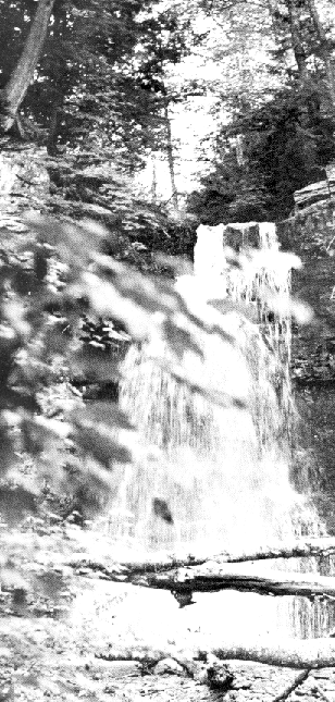
I've been looking through summer camp yearbooks that were made and printed in the early to mid-70s. (For a few years we diligently took photos of every village and sometime in the winter put together and mailed to every camper and staff member an honest-to-goodness yearbook. They're rare now, although a few of us have them, and they are also on display in the Historical Room of the Ad Office at camp.) In the yearbook for 1973 the photos are all of the villages and candids of kids and staff doing activities. But one is a nice black-and-white shot of High Falls. The reproduction here doesn't do it justice.

Most of us have hiked to High Falls many times, and probably almost all of us have camped there, at one of the two overnight sites ("High Falls Lower" or "High Falls Upper"). But few of us have hiked along the brook above the falls. I recommend it with great enthusiasm. In fact, if you keep hiking along the brook you will find yourself turning to the northeast and climbing near the western ridge of Doubletop Mountain. Yes, High Falls Brook to the west and Pigeon Brook to the east are the two streams bounding the Frost Valley side of Doubletop. Many FV'ers know that by hiking up Pigeon you can get close to the Doubletop's peaks. Few know that the same is true of High Falls Brook. So try it. It's a difficult climb - goes up steep angles toward the end. And then, depending on the time of year, the brook ends sooner or later at its muddy and swampy and brambly beginning, and then you must (as always on Doubletop) use a compass to go the rest of the way. There are several beautiful little waterfalls above High Falls, and while in aesthetic terms HF Brook is a C+ to Piegon's A+, it is worth doing if only because so few do it.

Saturday, July 7, 2007

1963 hike

Homer McLemore leads Lenape campers on an overnight hike, 1963. Homer identified the campers for me: R. Lewis, M. Pitcher, P. Cole, R. Scharf, R. Gershem, R. Schiffman, R. Pimenthal, D. Eisman. Check out the white Wawayanda sweatshirt. I once owned several of these gems. And the Wawayanda sailor hats were de facto uniform, especially on overnight hikes. I can remember that for a few years we carried out of a camp a #10 can of baked beans: at dinner time, we opened the can a little, stuck it in a campfire, stirred often and ate beans with our roasted hot dogs. Well, that was in 1967 or so. Homer's group here is '63 and I'll be they brought some more legit food for their overnight. (Could these kids really be in Lenape? The seem a bit young.)